deltagearinc
-
Content
4 -
Joined
-
Last visited
Never -
Feedback
0%
Everything posted by deltagearinc
-
Sorry if I offended anyone with my reviews, but I review products with the general public in mind. Just sent my Flight HUD and FlySight data from my test jumps to Bionic Avionics and Paralog. I'm excited to see Flight HUD integration with FlySight Viewer and Paralog. Thanks for the updated file, MrCat!
-
Skywombat has made a tool that converts the recon files into gpx format that paralog and Google Earth can open. It's on this thread http://www.dropzone.com/cgi-bin/forum/gforum.cgi?do=post_view_flat;post=4389509;page=9;sb=post_latest_reply;so=ASC;mh=25; It works well Thank you for the link. I tried to download the zip several times and the status bar had "waiting for github.com..." while the page attempted to load for half an hour. Other pages were loading fine. Also, the terminal interface and Mac instructions aren't very well suited for the general public. I also didn't have good results with the following online converter: http://www.jori.ws/recon_decode/ QUICK UPDATE: MrCat was kind enough to send me the zip file, but it didn't work in 64 bit Windows and the Mac instructions are pretty ridiculous. I try my best to avoid free dev work - so until the competition fixes their products, I'll stick with FlySight.
-
Skywombat has made a tool that converts the recon files into gpx format that paralog and Google Earth can open. It's on this thread http://www.dropzone.com/cgi-bin/forum/gforum.cgi?do=post_view_flat;post=4389509;page=9;sb=post_latest_reply;so=ASC;mh=25; It works well Thank you for the link. I tried to download the zip several times and the status bar had "waiting for github.com..." while the page attempted to load for half an hour. Other pages were loading fine. Also, the terminal interface and Mac instructions aren't very well suited for the general public. I also didn't have good results with the following online converter: http://www.jori.ws/recon_decode/
-
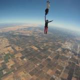
I recently tested the Flight HUD from Recon Instruments, the FlySight from Bionic Avionics, and the Skydiver GPS app. I wasn't able to load the Flight HUD's data into Google Earth, but Recon is working on a Google Earth export feature. Recon's online analytics software, called Engage, is limited when looking at jump metrics and is better suited for looking at ski/snowboard runs. Recon is working on software and firmware updates, so at the moment this leaves the FlySight and Skydiver GPS app up for comparison. First let's look at the hardware of the iPhone and FlySight. Compared to the iPhone GPS, the FlySight's purpose-built GPS shines. The iPhone was designed with tight space constraints, particularly with regard to antenna size—the first “line of defense” against noise for any GPS. Ordinarily, the iPhone gets around this fact by using cell towers to narrow things down quickly. However, at altitude those signals aren’t available, so the fix quality suffers quite a bit. This is evident in the Google Earth plots when the Skydiver GPS app data shows altitude increasing at times during free-fall (currently impossible unless you're wingsuiting and ground effect comes into play or your name is Yves Rossy), while the FlySight data shows a constant descent. You can also see the Skydiver GPS app doesn't get a strong signal lock until after I've already exited. Once under canopy, Skydiver GPS and FlySight data were very close to one another. Not only is the FlySight's data the most accurate, it also easily works in either the FlySight Viewer or Paralog. Both are extremely flexible analytic tools. FlySight Viewer allows you to stack or combine graphs, and the variables for each axis are configurable. See your elevation, horizontal speed, vertical speed, total speed, or glide ratio versus time or distance. So when it comes to software and the FlySight, you have options! When exporting data from the FlySight Viewer as a .KML file and opening it in Google Earth, the default setting for Google Earth is to have altitude “clamped to ground”. If you right-click on the imported layer, then go to Get Info (Properties), change to the Altitude tab, and change the drop-down to “absolute”, you should see the full 3D view of your flight. FlySight also provides real-time feedback, which allows you to correct your body position on the spot. Recon's Flight HUD also provides real-time feedback but at a slower 1Hz versus FlySight's 5Hz, which means it has the potential to be a contender and I look forward to future updates from Recon. Skydiver GPS is not as full featured or accurate due to the phone's hardware, but it is free and extremely user friendly. Without a doubt, FlySight is still the reigning champion. http://flic.kr/p/dSWHHu
-

-
-
While the Parachute Center is not known for it's great looks or amazing personality, it is the best DZ in the world to crank out a bunch of jumps. Lodi is half the price of most other DZs, and here's why. The Parachute Center is a no frills, well oiled, jumping machine. This isn't a USPA sanctioned drop zone, which is evident by the fact that most jumpers don't wear helmets or seat-belts on take-off. Despite that fact, this is one of the safer drop zones and you will frequently find a skygod correcting someone's risky behavior. The accommodations include concrete floored bathrooms, corrugated metal hangers, and a bunch of couches. While the construction isn't much to look at, it is kind of homey with a lot of nostalgia. Bill, the owner, is behind the counter seven days a week and he ensures that everything is maintained day after day. He is infamous for "firing" employees, customers, and pets. Complaining, dangerous behavior, incompetence, poorly behaved pets... well pretty much anything that slows down his well oiled machine are cause for being "fired". Some employees may appear to be stressed, frustrated, or angry due to the high paced environment, hot weather, Bills propensity to fire people, and the inexperience of novice jumpers. But for the most part, the Parachute Center has a good cast of characters that are talented and EXTREMELY experienced. On any given weekend day, the Parachute Center runs two planes simultaneously and can crank out an amazing 40+ plane loads of people (average DZs do 10-20 plane loads). On a weekday you will find one plane running and they will do half as many loads. BUT you can still do about the same number of jumps, just much more comfortably. The weather is really constant and usually consists of a steady mild breeze. So planes run all day until there aren't enough people for a full load, which usually happens in the late afternoon. The vibe is exactly what you would expect... all business. No music in the DZ. Just the cycling of the tandem instruction tape (all.day.long.), and an intercom calling out tandem numbers (or "load next"). Gear sales range from some basics (i.e. goggles, glasses, log books, etc.) to some apparel. The staff consists of experienced instructors, good videographers, and nationally known riggers. Wireless internet is available. Sleeping accommodations include a bunk house, a packing hanger, or you can camp on the lawn. A handful of employees live on site, which makes for nice low-key evening BBQs. The local area is riddled with taco trucks for some delicious well priced food. Overall, a great place to knock out some serious training or get an inexpensive tandem ride. You will not jump anywhere else in the world for less.
-
Water training at the Jim Wallace School was money well spent. Calling and making reservations was a little confusing since the Jim Wallace School is located on the same property as Skydive Perris, but it is ran independently by Jim (call his school directly). On my way to training, I thought this was going to be just another hoop to jump through on my way to my B License... but Jim's water training was anything but that. Jim Wallace provided excellent water training, and was able to share his vast experience doing water landings for films and demonstrations. The classroom portion delivered a lot of potentially life saving information quickly. He taught us both the text book answers along with real world solutions. Jim shared personal experiences where his friends/fellow-jumpers drowned, and he taught me how to avoid these deadly situations. I am proud to have been trained by Jim Wallace, and would recommend his water training to anyone that doesn't want to drown under canopy.
-
Hollister Airport, 45 miles south of San Jose is home to best staff and group of fun jumpers in all of California. Skydive Hollister is notorious for their off-site landing area, "420-up" Cypress setting, and short bus ride back to the DZ for all the "special kids". Gear sales include altimeters, eye wear, apparel, and used canopies & containers. You can jump during the week with an appointment, or jump all day on the weekends. While other DZs in the area close early, Skydive Hollister lets you enjoy beautiful sunset loads. Skydive Hollister takes customer service to the next level. Their staff is skilled, friendly, talented, safe, and fun. You'll find AMAZING cameramen with the skills of skygods, but without the ego and attitude. Frequently on weekends, after a long day of jumping, you will find BBQ and beer (courtesy of first timers = "case of beer"...only the good stuff / no canned beer). Whether you're a first time tandem, AFF student, or experienced fun jumper, there's a place for you at Skydive Hollister. Skydive Hollister has a PAK, which will take you to 13.5k. The PAK is slower to altitude but descends quickly and can cycle loads just as fast as other planes over a course of a day. The facilities are cozy and spacious, and good music always sets a cool vibe. Wireless internet is available if you ask nicely for the password. Sleeping accommodations include a bunk house, plenty of couches, or you can camp on the lawn. Prices are average for an experience with an above average staff. If blocks of jumps weren't such a big investment, I would call Skydive Hollister home in a heartbeat... but it will always be my home DZ at heart.
-
Marina Airport, 50 miles south of San Jose and just north of Monterey provides amazing views from the air. Gear sales range from some basics (i.e. goggles, glasses, log books, etc.) to some apparel. Jumps are mainly geared towards tandems and AFF students may feel like they are second priority. Great instructors, riggers, and videographers. The office staff can make your experience fun or stressful, depending on who you talk to. Prices are reasonable for the extra altitude and views. Skydive Monterey Bay has a King Air that will take you to 18k in under 20min... a big plus! The facilities are fair, and the gear and plane are well maintained. Wireless internet is not provided, but is obtainable. Unfortunately, there is no bunk house, couch to crash on, or place to camp at the DZ. Overall, it is a fantastic DZ to experience but not a place to call home.