

the.Legend
-
Content
120 -
Joined
-
Last visited
-
Days Won
1 -
Feedback
N/A
Posts posted by the.Legend
-
-
So far this prototype that can display whatever data I need, and I'm working on different layouts and overall stability.
Since the device doesn't have a barometer, the altitude is based on GPS. It has some pros and cons:
+ Displays real altitude relative to the ground (after MSL/AGL offset is stored in memory via corresponding menu)
+ Burble does not impact readings - true altitude displayed regardless of back/belly position
+ You see the same altitude as the one used by judges during scoring ( because Exit and Start/Finish gates are read from GPS, and AGL offset if preset in the beginning of competition) - last year during championship there was a case when Visio and FlySight altitudes were different by few hundred meters, and competitors were to exit an aircraft at 3700m AGL according to GPS, not barometer reading
- If signal is weak (i.e. too few satellites in view) the altitude readings swing back and forth by astronomical margins (sometimes as much as 400m) - I'm working on improving signal reception
With time I'll release a web-tool for creating custom layouts so anyone could see whatever they want (actually, the tool is already in working state, but now I need to implement support for JSON definition of layouts)
-
The first prototype that will be used by someone other than me :)
I've pretty much settled on hardware configuration. There's still some space for optimization (like size for example) but that shouldn't affect the codebase too much.
ENGO 2 indeed pretty good for this purpose. Although there was no SDK for ESP32, I was able to write some basic implementation using the documentation available.
Still there's a lot of work to be done. In the sort term:
* Complete "Competition mode' - UI tweaks, navigation, score computation
* Implement data input - home DZ coordinates, altitude offset, target coordinates for competition, etc.
* Stability overhaul
In the long run it'd be good to have some smartphone app to manage all the settings, as well as create custom screen layouts, but there's still long road ahead

-
 1
1
-
-
Maybe their old number still works
Phone : 770-279-7733
If not, attached are the lineset specs pdf, maybe some rigger would help you
-
-
AAD servicing - especially:
1) Auto-shutdown feature of Vigils (idk about Cypress) - reminder to turn AAD off at the end of the day manually because they will shut themselves down after 14 hours, but if you leave the rig at DZ overnight with AAD On, it may shut itself down juuust in-between the rig check and boarding the your firts load the next day
2) battery servicing periods for different models
3) Activation altitudes and speeds for different modes
-
There's no such perfect spot. It's always a balance between snag hazard and the picture
Full body view could be achieved by having camera far from the body i.e. selfie stick, but this is dangerous on many levels. I could give a full lecture about why this is a bad idea, but key points:
* If you loose it, it might fail on someone's head or property
* At terminal velocity it catches air like crazy and affects your flying a lot
* Snag hazard
* In case of accident/malfunction when you need both hands, what you gonna do with the camera?
Just don't do that.
Next on the list - helmet camera extensions - they've got their name "deathsticks" for a reason. Avoid that as well.
Wrist mounts are widely used by tandem pilots, but those jumps are of completely different nature, shoot specific angles and thus wrist mounts work well only in that environment. Also those mounts have cutaway mechanism.
I've seen some people with 360 camera chin mounts, which is comparably safe, but again, no full body view.
You know, actually, there's one perfect spot that lets you see your whole body - when it's mounted on the helmet of your coach.
-
2
-
-
@Annik Which type of lens were you using? And did you use them with clear visor or tinted visor? How do they stand against bright daylight?
After deeper investigation and consultations, I'll be experimenting with them because the platform seems very promising, easy to integrate and solves a lot of technical & safety challenges.
If all goes well, there gonna be a pretty cool announcement soon :)
-
Parachute De France has been changing owners many times, no wonder it's hard to find any information.
That's some kind of main ("Principale") but the stamp is not very readable on this photo, so you'd have to check the archives yourself:
https://web.archive.org/web/20130315000000*/http://www.aerazur.com/en/
https://web.archive.org/web/20230000000000*/http://www.parachutes-de-france.net/
-
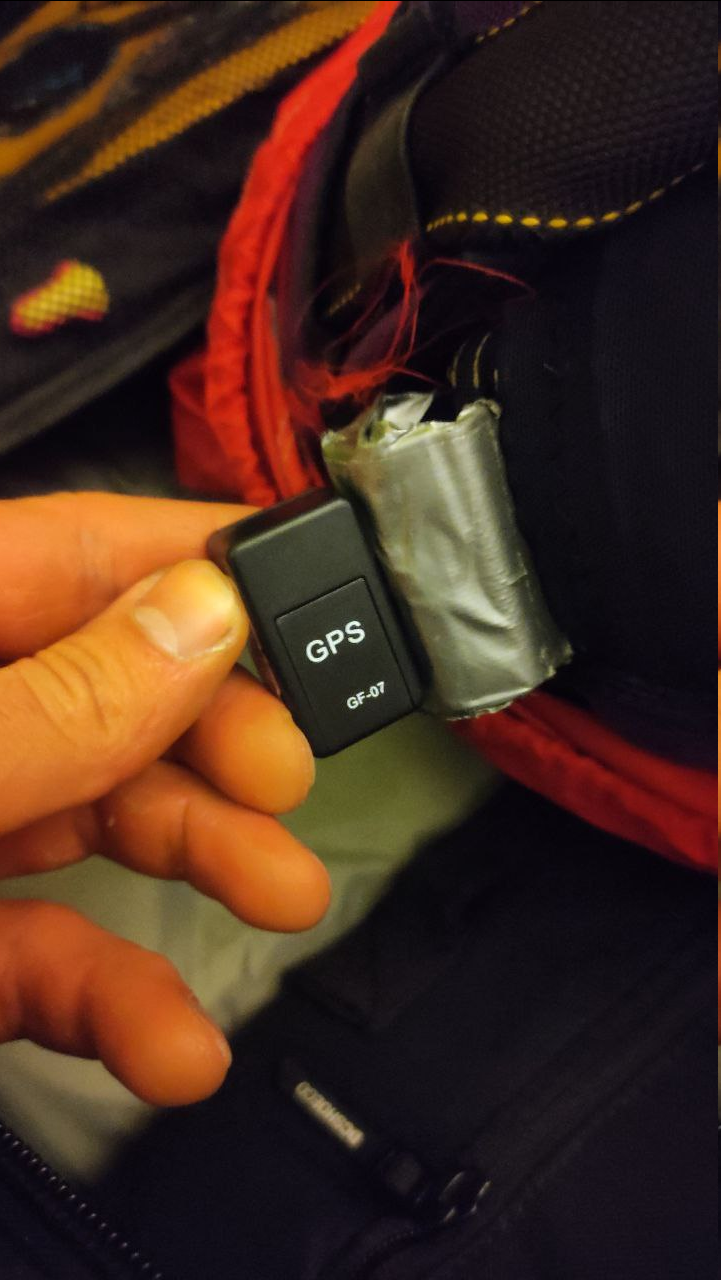
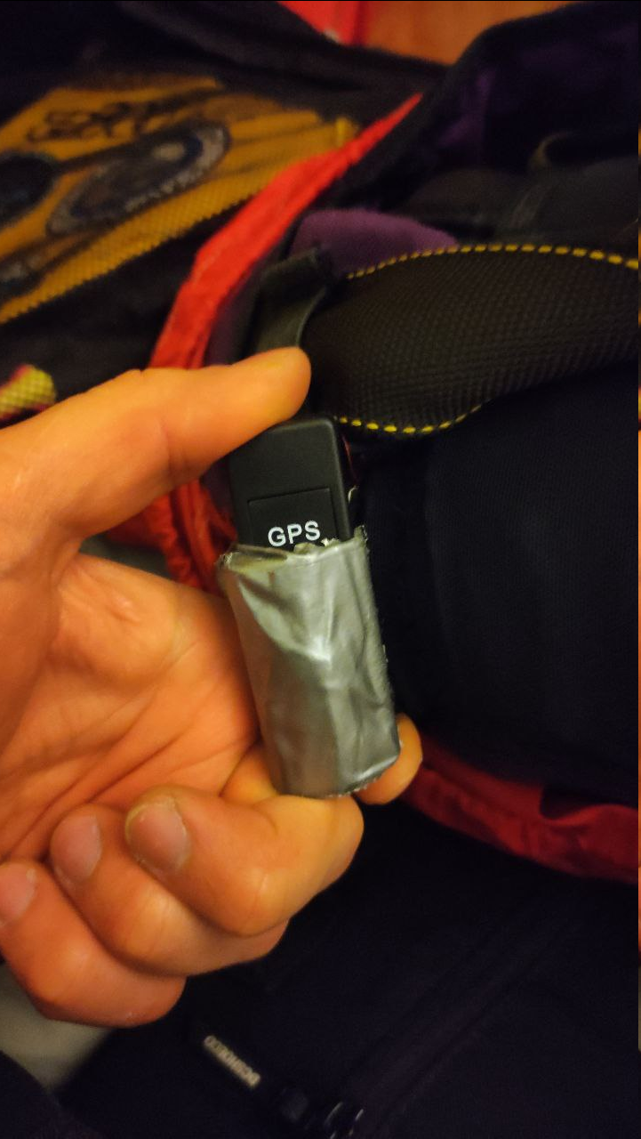
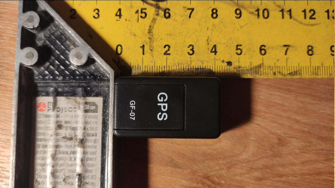
So my tracker from AliExpress has finally arrived. Size-wise it looks good - nearly perfect fit for SkySnatch's pipe handle
But turns out this is not a GPS, rather GPRS tracker, just like this review says:
https://www.youtube.com/watch?v=FsMKcn3R2tQ
(I wish I've seen it sooner)
Checked its insides and indeed there's no GPS hardware. Technically you may use it along with call capabilities - i.e. look for a canopy by making noise and listening how close you get to the point, but IMHO its not worth the effort of installing it. Will search for something similar, but with real GPS capabilities
-
As of October - still Havoks. I've heard some talks about switching to new Intrudair Fin, but it's the same as last year's talk as switching to LowKi - i.e. time will tell.
Anyways this shift would probably be gradual because they have full shelve of perfectly operational Havoks with some lifespan left in them.
-
Looks like old Vertigo's canopy for BASE jumping (nowadays it's known as APEX BASE)
-
Just a side note: that link shows only USPA-affiliated DZs.
-
18 hours ago, gowlerk said:Roll it up, put it in a plastic bag, put the bag in the back of a closet, and forget about it until years later then throw it in the garbage. That's what I would do.
What a waste of perfectly good material! Few month ago I got a jacket from Skylark made of parachute fabric and it's amazing! Wind/water-proof, very light and compact. I carry it in a backpack anywhere I go.
-
Well, just lay it on the ground and measure the area in sqft (length x width) :) It may not be 100% accurate, but you'll know what's the closest size to look for in manufacturer's catalogue
-
1
-
-
It also has some BASE exits. You might want to reach out to @platypii who created it and put few more locations :)
And if you're into speedflying/paragliding then use this one too: http://www.paraglidingearth.com/
-
1
-
-
According to their VK page, Pro-flyers rate is 18 000 RUB (that's around 195 USD)
https://vk.com/market-186941659?screen=group&w=product-186941659_7196687%2Fquery
The tunnel is 5 meters in diameterIf you think about paying them a visit I'd be really really careful - not only this is Russia, but Gudermes is only 40 km from Grozny - the capital of Chechen republic. A republic where even Russian authorities have little to none authority.
Random Americans sometimes become pretty good hostages for future prisoner swaps. Just saying.
If you just want to get the more information they left this phone number for enquirers: +7 995 811 55 77 though IDK if they speak English
-
1
-
-
I don't think many would focus on Yepzon because it's a bit of too much effort. I don't see UART pins on the board, so probably it's all via JTAG (i.e. USB) which is a bit more complex
Thus the only reason to hack into this device for I see would be as a personal challenge, because there are few alternatives that require significantly less effort and skills:
* No-brainer - sew an AirTag into your freebag
* GPS tracker from AliExpress ( additionally you may install own opensource GPS tracking server like OpenGTS)
You can then 3D print a custom pilot chute handle to serve as casing for the devicehttps://www.aliexpress.com/item/1005006032717925.html
folks from Empuria brava already doing something similar:
https://empuriabravarigging.com/gps-handle/* Build your own device:
https://www.instructables.com/Homemade-Realtime-GPS-Tracker-SIM800L-Ublox-NEO-6M/
use Seeeduino or Adafruit Trinket to save space
List is sorted in ascending order by skills & effort required
UPD: I just ordered one from China, will do its review keep you posted
-
Please describe in more details what you mean by "best"? I.e. which characteristics you're looking for?
Are line twists your only concern, or you want something maybe a bit less "stable" but more performance that can reliably get you from the long spot? Do you pack yourself or not? Would you like softer slower openings or normal are fine? etc...
Apart from canopy you might want to look at pilot chute too - something like Skysnatch 2 or its less-advertised alternatives
-
1
-
-
+1 for DaVinci Resolve - the best free tool on the market, with lots of features that you'd usually find only in expensive programs.
Another big plus is that on its website there are really good and really helpful video tutorials, which I highly recommend watching.
This tool replaced Adobe Premiere for me. Its only weakness so far is lack of compatibility with Insta360 format, but it's manageable.
Available for all platforms (Windows, Mac, Linux)
-
1
-
-
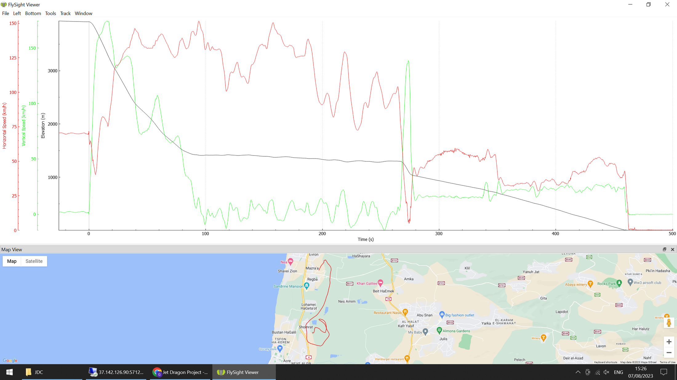
On 8/7/2023 at 2:31 PM, Gideon Yampolsky said:Results so far ... 6L of fuel consumed. I'm still learning how to fly it efficiently
Congratulations on pulling this off!
May I ask what's the biggest challenge in maintaining constant horizontal speed? Did you have thrusters "On" at constant RPM all the time or was it impulse acceleration? -
Late response, but might be useful to someone: about a week ago I've been to Stockholm's WS tunnel and they still have one or two Low-Ki demo suits to try (don't remember which sizes), as well as ATC (most sizes), and if you ask in advance, Freak 5
Drop them an email and ask for details
-
Obsidian has been in making for few years already (last news dates 2021), and it might still take them some time to get it to the market - pre-order summer 2023 with 100 units
I'd be keen to test it but I can tell you already it will not be a good match for competitors
from their own FAQ:
QuoteDoes it have GPS?
No, Project Obsidian does NOT have a GPS receiver. It will be able to receive GPS data from another device (like a smartphone) via Bluetooth Low Energy.
Smartphone GPS is 1Hz which is not enough. I tried this frequency in my early prototypes and speed change feedback is too slow. 5Hz like in FlySight is optimal. What's more, depending on phone's firmware, at high vertical speeds some phones go crazy and stop sending their readings.
I'm wondering if Obsidian would be able to display anything else apart from plain numbers - majority of competitors I've spoken to don't actually care about ground speed or GL as much as they do about hitting the gates as precisely as possible to perfectly time the flare, and staying in the lane to avoid penalties.
BTW after a long fight with the library I've finally switched to UBX protocol and now can calculate all the data exactly as the FlySight does, so what you'll see on display will be exactly what will be in scoring on the ground
-
The cheapest one is in Venezuela - 230$ per hour excluding coaching.
But other than the price you should ask yourself what exactly you'd like to train. The further you progress, the more you tend to seek people who fly well and teach well, and that's not something every tunnel can offer. Also you'd start noticing the quality of the wind is not the same across the tunnel brands, with some offering more consistent and stable airflow.
In Europe AFAIK Poland, Finland and Sweden offer the cheapest hours
Complete list of tunnels around the world:
-
1
-
-
Not a base jumper, but a person who came back to skydiving after a very serious spine injury. One thing that helps me mitigate the risks and shocks is strong core muscles. A good physiotherapist or trainer would help you build a corset of muscles around your back which should make it safer for you, especially on rough landings which are more frequent in base jumping.
If money is the issue, a smartphone app called "6 pack promise" from Athlean-X is very good at strengthening all the necessary muscles. Out of all apps that I've tried this one worked the best.


HUD dashboard development
in Wing Suit Flying
When I started, there was nothing of that kind, so through trials and errors it's now where it is. Smartphones aren't good enough because their GPS is too slow (only 1 reading per second).
Since I don't have Garmin watch I can't comment on that.
ActiveLook became available only about a year or two ago, but when this project has started there was no hardware on the market that could provide the solution at a reasonable price and scalability.
Yes, FlySight 2 has technical capabilities of working with ActiveLook, it's only a matter of firmware update. Although its UI will be a bit cumbersome because there's only 1 button on FlySight and proximity sensor on goggles (which doesn't recognize swipe directions, only that there's a swipe). Or it will rely on config files that have to be uploaded from PC.
I've been considering making custom firmware for FlySight but at this point it's faster for me to experiment with the code I already know because functionality is constantly changing.
Who knows, maybe at some point it will be merged into FS.