0
dzjnky

What is a "perfect" flock anyways???

Recommended Posts

I am starting a new thread for this discussion so we can separate all the well-deserved high-fives for the Elsinore and Eloy flocks from the conversation about how to measure future attempts.

All you motherflockers are keeping me up when I should be resting - my mind is just racing along thinking about how to measure a perfect flock... The good news is that technology is constantly getting better, and there is a program under way to develop "High Accuracy Differential GPS" (HA-DGPS) with an accuracy in the neighborhood of 10-20 cm depending on axis. Unfortunately, it is still under development by the US Federal Government, and is subject to the funding cuts, politics, etc. of being a federal project. As far as I have been able to learn online, there are only 3 base stations in the USA that are broadcasting the HA-DGPS corrections, and I doubt there is any commercially available equipment that will support it yet. In any case, that accuracy would be enough to "judge" flier position pretty well. So the concept floated by "unclecharlie95" on another thread may very well be a good core concept.

As I think about it harder, though, we probably don't care in an absolute sense where the flock is - what is important is a time-referenced distance from other fliers in the flock - and sufficient relative accuracy may be available with the current technology. Clearly some experimentation is in order, as well as some discussions with GPS knowlegable folks (manufacturers?), and I may see what I can pull off along those lines either over the winter, or early next season (it is getting cold up here in New England).

However, all this technology is useless unless we can agree upon what is a perfect flock - how do we measure this beast??? One concept floated is this "grid" thing, where everyone must be "in their box" throughout the entire flock. Very difficult, as this forces the back row to be in exactly the right place relative to fliers that they probably cannot see who may be 200+ feet away. It will make for a truly impressive flock, extremely uniform! But it does "up the ante" in that it is exceptionally difficult to pull off, especially as the flocks grow larger. Maybe that by itself makes that yardstick the "gold standard" to shoot for....

Another idea floated was the "movable grid", where a 5x5 grid is moved around the flock, thus forcing the flock to be "locally perfect" yet allow some breathing across the overall formation. Is 5x5 the right size? Should it change based on the size of the formation? Is the flock a "non-record jump" if there is ANY position of the 5x5 grid over the flock that can't fit all wingsuits in their appropriate box? Does ALL of each wingsuit have to be in their box, or just the pilot's head??? (I'm thinking ahead to where GPS units might be located). We need to agree upon what makes up a perfect flock. We also need to decide what is "perfect" for levels in addition to just the X and Y coordinates. Are those 3m x 3m boxes also 3 m tall??? Is 3 m the "right" size??? In all directions? For all flocks?

If we can get better data about how accurate GPS really is today, especially when used relative to other GPS receivers in close proximity, the opportunities for detailed analysis of the flocks become very interesting indeed, and the logistics of analyzing all that data are also quite a challenge.

Please, throw in your thoughts on this - I am really intrigued with this the more I think about it... Does anyone have any other ideas on what constitutes a "measurably perfect" flock???? Thanks in advance for helping brainstorm this - be bold, post all your ideas, good, bad, or ugly. Risk getting flamed for the collective good :). As you can see, I had earlier shot down an idea from unclecharlie95 that I didn't think would work, but on additional reflection, it may work after all - my focus was too narrow initially... had to think "out of the box" to figure out how to measure the box :S Let's come up with a collective solution to this!

Share this post


Link to post
Share on other sites
One "down-side" that comes to mind about any GPS-based solution... the data collection logistics probably mean that a GPS-based solution will only be usable as an end-of-day "forensic" (i.e. after the fact) analysis tool - I don't see a way to collect and process the data quickly enough to use it as a debrief tool. And even if you could collect and process the data quickly, visualization of it as a debrief tool would require some significant software development.

The big positive, though, is that GPS data, for this purpose, is probably pretty bullet proof, so it would probably see broader acceptance as being "official". Getting that many (100?) GPS pucks to all function perfectly all day long (or at least on the key jumps) may be a challenge in and of itself... and like a 4-way team not getting video, if one GPS puck failed to record the jump, that probably would invalidate the entire data set for the jump. Would "video backup" of the jumper with the "bad puck" be sufficient to validate the jump??? Another point to contemplate...

Share this post


Link to post
Share on other sites
Differential GPS uses a GPS receiver that's also able to broadcast. Normally you locate this device over a known location on the ground. The broadcasting device broadcasts what the current error is between the GPS position and the known location on the ground. Other GPS receivers then use that error to correct their positions ... to centimeter accuracy.

Now if the base carried such a device, it could broadcast the GPS fix of the base. Other differential equiped GPS units could then determine their location relative to the base to cm accuracy. I don't know of any cheap GPS pucks with the differential capability.

Of course, you'd have to develop some pretty specialized s/w to integrate all the unit's data, not to mention that getting it all into a PC would be tedious at best. Still, that would only help for post-jump analysis.

If only we had a viable heads-up display ...

Share this post


Link to post
Share on other sites
first of all, thanks for taking this to a new thread... it was about time :)

Quote

Getting that many (100?) GPS pucks to all function perfectly all day long (or at least on the key jumps) may be a challenge in and of itself... and like a 4-way team not getting video, if one GPS puck failed to record the jump, that probably would invalidate the entire data set for the jump. Would "video backup" of the jumper with the "bad puck" be sufficient to validate the jump??? Another point to contemplate...


if the jumper with a failing GPS unit is located somewhere in the middle of the flock, such that there are at least a few flockers around him/her in any direction, it shouldn't be a big problem.
If you have functioning units to the right, left, front and back, you can more or less determine the position of the bad GPS guy by interpolating the coordinates from the neighbors.
As long as the video shows that the person is in the right location more or less (meaning not completely outside of the slot or something), you should have all the data needed to determine if they're flying their box or not.
In fact, if you take the local picture of the bad GPS dude with the neighbors and assign the neighbors their respective coordinates, at that point you can pretty accurately compute the location of the bad GPS dude.
As I think about this more, you don't even need immediate neighbors. I think it might be sufficient to have a bunch of working GPS's to properly frame the formation... maybe a few more scattered inside, for error correction or something... and that, combined with photo/video, might be enough at this point. Having the coordinates in place would also allow you to determine if there's any need to correct for lens distortion.

Share this post


Link to post
Share on other sites
I have spent a lot of time and still do , testing out GPS systems in a skydiving environment for the government. I can tell you that the idea of using DGPS is not as easy or practical as it may seem. A thread on this topic and some of the issues from last year can be seen here.

The thing that people seem to be forgetting in all of this hoopla is that the judging criteria must be something that can be done and or practiced by the average skydiver at the smallest DZ anywhere in the world and evaluated by a judge who might not even know how to fly a wingsuit. A system that requires the users have specialized equipment attached to them and or on the ground and that requires an above average knowledge of post processing of the data is not a viable solution.

Likewise, one still photo cannot be used as a means of determining the outcome as it represents at best, 1/500th of a second that the formation was in a certain configuration. If any of the grid type solutions that have been mentioned were to be used, it would have to utilize video footage. And like RW bigways, the grips would need to be held for a determined amount of time or in the case of wingsuiting, based on the formation, the participants would all have to be in their prescribed box for X amount of time. As mentioned, another issue with the grid judging criteria is that based on the shape of the formation, ie: on different levels, there would have to be a means to judge vertical as well as horizontal distance between jumpers on multi level formations. Doing either is not easy and or entirely do-able given the fluid nature of wingsuit formations.
"It's just skydiving..additional drama is not required"
Some people dream about flying, I live my dream
SKYMONKEY PUBLISHING

Share this post


Link to post
Share on other sites
Just to be a troublesome newbie isn't a lot of this like when a seasoned wingsuiter tells a newbie to not worry about the numbers and just go out and have fun and learn to fly your body and fly it with other people? You guys got 71 wingsuiters together in a formation that was understandable and clean. What more do you want. Do you really want to make it a complicated process with a lot of additional technology? It sends mixed messages when you tell a newbie not to worry about numbers when you are doing just that. Flame on...
Sky Canyon Wingsuiters

Share this post


Link to post
Share on other sites
Quote

Just to be a troublesome newbie It sends mixed messages when you tell a newbie not to worry about numbers when you are doing just that. Flame on...


I, and a few others tell people not to fixate on the tech and the numbers. Scott and few other Love the GPS, the tech and the numbers. There is plenty for everybody here.

Share this post


Link to post
Share on other sites
notsane & LouDiamond - I was wondering if we could just compare the tracks of multiple "standard" GPS receivers without using DGPS. All the GPS units use the same time signal, and should be subject to the same timing errors, so you can time-align the tracks, and then compare what each GPS unit reports for a position at any given point in time.

LouDiamond commented in the other thread that he pointed to:
Quote

However,if you are using a standard GPS reciever on all the jumpers, they will all have a margin of error that varies from receiver to receiver in the NMEA stream anyways.


The "margin of error varies from receiver to receiver" is the part that bothers me... is this due to manufacturing variances, or ??? I initially was thinking that GPS receivers were digital devices, but in the reading that I have done in the past 24 hours, I am starting to think they are analog devices with a digital output. Scott C - can you confirm that guess?

If the receivers are basically analog devices, then I understand why there is unit to unit variations, but then I get confused on how that unit to unit variation gets cleaned up in DGPS - don't all participating DGPS receivers get the same correction code? If so, how does that clean up the unit to unit variation? I guess I have a lot of learning to do on how GPS really works...

My naive hope was that all the various receivers would have the same error, so in absolute terms you would only know where the flock is within "standard" GPS tolerance, however if all the receivers have the same absolute error, then you can get a VERY accurate measure of the relative distance between receivers, which is what we are really interested in. How accurate, I don't know, as we are now really talking about how big the unit to unit variations are. Do the unit to unit errors change over time? Maybe you can calibrate it out by putting all the receivers in one place prior to the jump, noting the deltas, then hand out the receivers and go jump? Would that "calibration" hold for the entire day? Do you need a second calibration at the end of the day? Would the error drift be linear with time? As I said, a I need a lot of learning about how GPS works.

Just realized that we also may have to sort out sampling errors (in time) - I wonder how close the GPS units really align their samples in time? In other words, if they sample once a second, do they all sample at "the top of the second" relative to the GPS time signal (which should be consistent across the receivers). Sounds like one of my experiments will be to throw several GPS units in my helmet, and compare tracks that I know vary by only centimeters, unless someone else has already collected that type of data.

SuperGirl - my current concern with your approach to tying the pictures to GPS data is how do you time-align the photos??? With video, you may be able to time-align exits (kind of like how a "slate" aligns the audio with the video). As you get further into the dive, though, errors in time can add up (is the video camera really running at EXACTLY the NTSC rate? What is the tolerance there?) For stills, is there a way to accurately timestamp them to align them with the GPS data? I wonder if you could tie the camera shutter switch to the GPS, and log a waypoint each time the shutter is clicked...

We gotta figure out how to walk before we can run, though... this will be an iterative process. Just like building large flocks, we will have to cut our teeth measuring small flocks, and then see if we can scale it up...

Share this post


Link to post
Share on other sites
Quote

Scott and few other Love the GPS, the tech and the numbers. There is plenty for everybody here.


Let me correct your perception. I see the GPS as another tool, just like an audible altimeter or any electronic device that can be used by a skydiver. Relying on any one of them as a sole means of measurement is unwise as they are not infallible. Used correctly, they can prove to be a valuable item to the individual skydiver for self evaluation.
"It's just skydiving..additional drama is not required"
Some people dream about flying, I live my dream
SKYMONKEY PUBLISHING

Share this post


Link to post
Share on other sites
Quote

Quote

Just to be a troublesome newbie It sends mixed messages when you tell a newbie not to worry about numbers when you are doing just that. Flame on...


I, and a few others tell people not to fixate on the tech and the numbers. Scott and few other Love the GPS, the tech and the numbers. There is plenty for everybody here.


I agree with VectorBoy's comment. I also tell newer jumpers to not worry about the numbers. They will learn more about flying by flying with others instead of harping on the numbers. Then again, if you are only flying solos, then about all you have to "play with" are the numbers (right, Lurch??? Lurch did this for years before the flock grew in Pepperell - now he doesn't focus on the numbers so much - but they are still a curiosity for both of us ;) ) But, the numbers are limited in their usefulness, and not much use for learning how to flock. If your goal is to claim really slow fall rates, and the accompanying long freefall delays, then by all means, chase the numbers.

However, as we start trying to claim "world records", there has been an outcry of "Yah???? Prove it!!!!" In other disciplines, there are accepted standards of what qualifies as a record jump. Stuff like everyone must be in their designated slot, holding their designated grips, for at least x seconds (not sure of that rule). And it must be validated through stills and/or video. This thread is an attempt to 1) define what constitutes a valid world record flock, and 2) figure out how to validate whether or not a specific skydive actually met the agreed upon criteria. Neither one of these two issues is easy, nor are they particularly useful for newer flockers who are doing smaller flocks.

Share this post


Link to post
Share on other sites
Quote

I see the GPS as another tool, just like an audible altimeter or any electronic device that can be used by a skydiver. Relying on any one of them as a sole means of measurement is unwise as they are not infallible. Used correctly, they can prove to be a valuable item to the individual skydiver for self evaluation.


Agreed. My question (among others) is can we extend this useful tool (GPS) to evaluate "flock quality"?

Share this post


Link to post
Share on other sites

Let me correct your perception. I see the GPS as another tool, just like an audible altimeter or any electronic device that can be used by a skydiver.


Yeaheah! my point exactly and you love it. Relax its not a slam..... but I bet you've tried more GPS units than wingsuits :ph34r: own it. You know how many GPS units I've played with while wingsuiting?!? You win .....Again!

Share this post


Link to post
Share on other sites
Along those lines why not make judgments based on the area the entire formation fits into? Because there are not grips and "breathing" takes place why not look at the formation as a whole? There have been plenty of RW formations which could be counted due to all grips being made, but it might not accurately represent the formation intended. i.e. one wacker curves too much or not enough. Draw a shape, scale it in such a way you can decide how many wingsuiters can optimally fit into it. If at any point or predetermined amount of time every flyer fits into that shape then it is a record. I guess what I am getting at is look at a record like a whole painting, rather than just a collection of brush strokes.
Sky Canyon Wingsuiters

Share this post


Link to post
Share on other sites
Quote

As I said, a I need a lot of learning about how GPS works


Rick, there is no easy way to address the many questions that you asked here. I would suggest you read some of the info that can be found on GPS online or at the book store. Google GPS accuracy for starters and you will see that in most civilian receivers, its quite common for there to be a +/- margin of error in meters. I've seen two identical receivers sitting right next to each other give different margin of error readings. Study up on DGPS and it will become apparent why it is more accurate than GPS and also why its not practical for our application.

There is a way to synchronize GPS data and photos together, it is called geo tagging
"It's just skydiving..additional drama is not required"
Some people dream about flying, I live my dream
SKYMONKEY PUBLISHING

Share this post


Link to post
Share on other sites
Quote


SuperGirl - my current concern with your approach to tying the pictures to GPS data is how do you time-align the photos??? With video, you may be able to time-align exits (kind of like how a "slate" aligns the audio with the video).


shit, good point... (scratches head)

Quote


As you get further into the dive, though, errors in time can add up (is the video camera really running at EXACTLY the NTSC rate?


you're right, we need some sort of timestamped waypoints...
can one at least assume that the rate is a constant one? in that case, having a begin and end synchronized timestamp on both camera and gps device could suffice to determine whatever is in between.

I have no experience with GPS units. But I'm thinking one could set it up with an LED output, such that whenever the GPS unit marks a waypoint, say, when you hit a button at the start of the dive, or every 10 seconds, or whatever, it would output a visual signal by lighting up that LED, which could be positioned somewhere in front of the camera lens, and hence be visible on the video. Kinda like the LED for the Optima. Then the camera could be synchronized with the camera flyer's GPS.

This is getting so fuckin complicated. Love it!:)

Share this post


Link to post
Share on other sites
Quote


Let me correct your perception. I see the GPS as another tool, just like an audible altimeter or any electronic device that can be used by a skydiver.


Yeaheah! my point exactly and you love it. Relax its not a slam..... but I bet you've tried more GPS units than wingsuits :ph34r: own it. You know how many GPS units I've played with while wingsuiting?!? You win .....Again!

I don't love it,it just so happens that I have a job that benefits from it use and affords me the opportunity to use it more than most , so it helps to be knowledgeable about it.
"It's just skydiving..additional drama is not required"
Some people dream about flying, I live my dream
SKYMONKEY PUBLISHING

Share this post


Link to post
Share on other sites
Quote


I don't love it,it just so happens that I have a job that benefits from it use.


Oh come on you love it just a little don't you?


Probably about as much as a guy with a flat tire enjoys using a jack. The rest of the time, not so much.
"It's just skydiving..additional drama is not required"
Some people dream about flying, I live my dream
SKYMONKEY PUBLISHING

Share this post


Link to post
Share on other sites
Remember the KISS concept----Keep it simple "something"...

Give each flyer two small paint gun pistols one in each hand and pointing outward at 90 degrees from the grippers. Each pistol will be adjusted to have only and "exactly" just a certain range desired... and the colors will vary depending on assigned slot in the formation. Then at a predetermined ditter altitude , eveyone fires their pistol at the flyer to each side. Then you land ,..and do an after jump lay-on-the -ground dirt-dive to see just where the different colors hit the participants. ... Simple and Fun!!! Have Tony fund the pistols since he will wind up selling many more replacement wingsuits.

I also want to invite all of you to the Stoney first annual wingsuit rodeo jousting tournament to be held wherever I can find a DZ outside the USA that will aloow us to conduct the event... Should we use "official" solid foam "stickers" or allow things like heavy rubber chickens to be thrown in the "open" expert category... I am a GO on this idea !..... does anyone seriously doubt that?
Life is what happens while we are making other plans.

Share this post


Link to post
Share on other sites
Yo Rick!

hen again, if you are only flying solos, then about all you have to "play with" are the numbers (right, Lurch???

Damn right. Numbers are important to me for technical reasons, performance measuring, ninja tricks and suit hacks. Flocking, its all relative. One mans dirty flying is another man's maxed out. Flocks, its all about hanging out with friends up in the sky.
Anyway heres a thought... I'm not sure if its more about judging it or a method for making a real gridperfect flock...
Brian Snarr and I got to talking about this at the event. He'd mentioned using lasers in a way that I thought wouldn't work, can't remember exactly what he said but figured maybe hes onto something there, and started imagining a setup done with off-the-shelf industrial laser counter/emitter/pickup modules.
Problem is the expense. When I thought about it for a bit I realized you could actually automate flock building and alignment. 45 degree lines off the lead bird, low intensity visible/IR, wide beam divergence meaning the line is a beam a foot wide at the far end of the formation with about a 5 foot wide fringe to the beam. Each jumper has a pickup module with output coupled to audio producing a tone varying in intensity by signal strength. We use this stuff routinely in industrial automation for object presence detection.
Jumpers either have beam repeaters on their tails/rigs to deal with beam obstructions, tune it so it deals with a large black area in the center of the beam and temporary total beam obstruction or you could go for REAL brutal accuracy, use two beams and keep all birds between the beams by that audio feedback. You get near your slot, you get tone. Get closer to perfectly aligned, tone gets louder? Higher? Lower? Faster. Whatever. You're probably looking at sticking a laser reflector return decal on each jumper to make it easy for the modules to see the jumpers buts thats trivial.

Totally doable actually but insanely expensive, several thousand dollars per bird minimum to pull it off. The modules themselves are 3-700$ each, the logic to make use of their output and make a "flock gps" protracklike gadget out of it would triple that or more, easily. Might be able to pull a few shortcuts with consumer bluetooth gear though, get these things to talk to a headset through a phone or even an Ipod or something.
The same tech can be used in a different way for true proximity/location sensing and feedback if all birds have 4 emitters and pickups on all sides getting yes/no/how close feedback either by audio or a simple line of LEDs across the bottom of the goggles would suffice. One of the modules I have in mind already has both a scaled numeric and bargraph display right on it, you could just bolt it to a fullface helmet.

But come on... do we really want to automate this? The expense required to pull off such an insanely complex effect would not match the return in effort needed to do it. We get robotic enough with it people will mistake us for RW guys or something. Couldn't we just sort of do it the old fashioned way, by, you know, improving our skills and stuff?
-B
Live and learn... or die, and teach by example.

Share this post


Link to post
Share on other sites

Interesting stuff, Lurch - figured you would build some industrial strength solution for us B|... but all the technology in the world won't help us if we can't decide what constitutes a perfect formation... I guess that can change from event to event, but to compare various formations in an attempt to create "official" records, we need a consistent judging criteria so there isn't any second guessing on whether "we got it" or not. So, while the technology is the fun part (for me, Lurch, and numerous others too!) we still need more discussion on what constitutes a "record-worthy flock".

Share this post


Link to post
Share on other sites
Well I can see a true "record" flock being one in which Mike didn't geek the camera, not even once, but he's GOT to geek it at least once for it to feel complete. I still have him on tape in what has got to be the longest camera geek EVER... I was like what the fuck, we're having a blast here, and just kept the cam on him. 37 seconds after exit he was still geekin' when we finally had to make the first turn and break the geeklock. I was like "Man. Doesn't your tongue dry out something wicked like that?"
Mike, you gotta get up here again ASAP n come freeze your ass off with us bro. We missya.
-B
Live and learn... or die, and teach by example.

Share this post


Link to post
Share on other sites
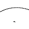
I think a slot perfect formation would not have to fit into a grid pattern as long as everybody was in the right place. Look at big formations of birds - their V will ripple with the wind, but they stay slot perfect. We should allow for this in our definition of the record or perfect flock. One pic of the 71 formation that I've seen would meet the criteria on one side, IMO, even though it was well off the grid. In any case, seeing the magnificent sight of so many flying so well, a record was achieved anyway. We may want to move the goal posts as we progress, but what a huge step forward our discipline has taken. Well done to all involved!
But what do I know?

Share this post


Link to post
Share on other sites

Join the conversation

You can post now and register later. If you have an account, sign in now to post with your account.
Note: Your post will require moderator approval before it will be visible.

Guest
Reply to this topic...

×   Pasted as rich text.   Paste as plain text instead

  Only 75 emoji are allowed.

×   Your link has been automatically embedded.   Display as a link instead

×   Your previous content has been restored.   Clear editor

×   You cannot paste images directly. Upload or insert images from URL.

0