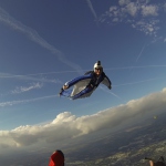
dthames 0 #1 March 18, 2013 I know for many years skydivers have been trained without the aid of nerdish gadgets. But if you want to get specific at where and how someone flew, a GPS recording of the flight can tell the story in amazing detail. It is also not open to “as I recall”, differing points of view. I only jump on the weekends. While waiting for the next weekend to roll around, I try to review what I did the last trip to the DZ and learn as much as I can. For tracking jumps and now wingsuit, where I flew is important for me to review before deployment. But the after deployment data might be useful as well. I don’t know if viewing a canopy flight with this level of detail would serve any real purpose in training or not. But a correct assessment of the flight can be made without personal perspective being a problem. Here are several screen images of a canopy flight and landing from a GPS recording made with a Flysight and displayed using Google Earth. The Flysight target market is the wingsuit community. I have no affiliation with Flysight. http://pyrodan.privatedata.com/skydive/NerdishViewCanopyFlight.pdf Instructor quote, “What's weird is that you're older than my dad!” Quote Share this post Link to post Share on other sites
sky12345 0 #2 March 18, 2013 QuoteBut a correct assessment of the flight can be made without personal perspective being a problem. sure.. but google earth is 8yo and gps is older than that yet no one needed to do "a correct assessment of the flight without personal perspective if ur talking bout disputes like "u cut me off!!! - no UUU cut me off!!!" then a camera is much more useful tool for that other than that, making love to gps tracks in google earth is soooo 2005-sh :D Quote Share this post Link to post Share on other sites
riggerrob 558 #3 March 19, 2013 Awesome training aid! How can we afford to hang one on every student????? Quote Share this post Link to post Share on other sites
airtwardo 6 #4 March 19, 2013 Quote Quote But a correct assessment of the flight can be made without personal perspective being a problem. sure.. but google earth is 8yo and gps is older than that yet no one needed to do "a correct assessment of the flight without personal perspective if ur talking bout disputes like "u cut me off!!! - no UUU cut me off!!!" then a camera is much more useful tool for that other than that, making love to gps tracks in google earth is soooo 2005-sh :D The 'learning' is part art & part science, from what I know of Dan (OP) he learns faster with the scientific data to reference. Nothing wrong with that...probably more like him than unlike him regarding processing this kind of information. The guy learns quite a bit from each & every jump...can't say that about a lotta 200 jump 'wonders'! ~ If you choke a Smurf, what color does it turn? ~ Quote Share this post Link to post Share on other sites
popsjumper 2 #5 March 22, 2013 Quote Quote Quote But a correct assessment of the flight can be made without personal perspective being a problem. sure.. but google earth is 8yo and gps is older than that yet no one needed to do "a correct assessment of the flight without personal perspective if ur talking bout disputes like "u cut me off!!! - no UUU cut me off!!!" then a camera is much more useful tool for that other than that, making love to gps tracks in google earth is soooo 2005-sh :D The 'learning' is part art & part science, from what I know of Dan (OP) he learns faster with the scientific data to reference. Nothing wrong with that...probably more like him than unlike him regarding processing this kind of information. The guy learns quite a bit from each & every jump...can't say that about a lotta 200 jump 'wonders'! Yep...Dan is one of the good ones.My reality and yours are quite different. I think we're all Bozos on this bus. Falcon5232, SCS8170, SCSA353, POPS9398, DS239 Quote Share this post Link to post Share on other sites
popsjumper 2 #6 March 22, 2013 QuoteAwesome training aid! How can we afford to hang one on every student????? Well, how many students do you want to put into the sky at the same time? Besides that, good luck with innovation when we can't even get some DZs to put students on different radio frequencies due to "cost". Right.My reality and yours are quite different. I think we're all Bozos on this bus. Falcon5232, SCS8170, SCSA353, POPS9398, DS239 Quote Share this post Link to post Share on other sites
dthames 0 #7 March 23, 2013 QuoteQuoteAwesome training aid! How can we afford to hang one on every student????? Well, how many students do you want to put into the sky at the same time? Besides that, good luck with innovation when we can't even get some DZs to put students on different radio frequencies due to "cost". Right. There are GPS recorders for smart phones. No cell tower connection is needed to record the GPS data, only if you try to get map data. I will test my Iphone the next time I jump and see if it does a fair job of recording compared to the Flysight. Looks like rain and low ceilings tomorrow.Instructor quote, “What's weird is that you're older than my dad!” Quote Share this post Link to post Share on other sites
dthames 0 #8 March 23, 2013 I downloaded an app for my Iphone that records GPS tracks for skiers. It might take some work but I think with a little effort a process could be developed where an Iphone could be used to record jump GPS data and make it easy to review. Two heads are always better than one. If there is anyone interested in helping let me know. Help with ideas, testing, programming, or whatever. DanInstructor quote, “What's weird is that you're older than my dad!” Quote Share this post Link to post Share on other sites
sky12345 0 #9 March 24, 2013 i tried iphone and it always lagged like crazy.. it showed altitude of where i was minutes ago >>>useless<<< Quote Share this post Link to post Share on other sites
HUPRA 0 #10 March 26, 2013 This is the first time I have seen something like this, so bear with me if I am asking a bone question. Is there any way of getting accurate height readings at points along your flight line, not just at deployment, for example to see the effectiveness of brakes vs rear risers for increasing range? Also, is the GPS accurate enough to give a swoop profile? Quote Share this post Link to post Share on other sites
Hellis 0 #11 March 26, 2013 QuoteThis is the first time I have seen something like this, so bear with me if I am asking a bone question. Is there any way of getting accurate height readings at points along your flight line, not just at deployment, for example to see the effectiveness of brakes vs rear risers for increasing range? Also, is the GPS accurate enough to give a swoop profile? Yes, and maybe. It all depends on how accurate you need the data to be. And what data do you need to be accurate. Height data is very hard for a GPS to read accurately, +- 2 m is not uncommon. Quote Share this post Link to post Share on other sites
dthames 0 #12 March 26, 2013 QuoteThis is the first time I have seen something like this, so bear with me if I am asking a bone question. Is there any way of getting accurate height readings at points along your flight line, not just at deployment, for example to see the effectiveness of brakes vs rear risers for increasing range? Also, is the GPS accurate enough to give a swoop profile? Hellis and I have been working to make ways for this data to be more meaningful. Hellis is writing code to massage the Flysight GPS data into charts and the Google Earth type file. The graph data for the canopy flight is the latest addition. I don't have examples to answer your questions but you can see the spiral and the change on horz speed caused by it. You can also easily determine how many feet down I went on each spiral revolution. I fly a very lightly loaded canopy and I can't old down the fronts. But I can pull down the outside A lines. I plan to do a test to see what that does for my ground speed. I want to know how much that will help me penetrate the wind. [inline canopy-extended.jpg]Instructor quote, “What's weird is that you're older than my dad!” Quote Share this post Link to post Share on other sites
potatoman 0 #13 March 26, 2013 I know the hang gliding guys use their androids, with great success to pull triangular etc maps of where they have flown. Calculates the sink/climb etc, from a $1 app. Can't remember the appname now. Would be nice if you could get the windspeed too. You could then seriously calculate a cross country jump, and then finally answer all those questions of where the best glide ratio is on a canopy.You have the right to your opinion, and I have the right to tell you how Fu***** stupid it is. Davelepka - "This isn't an x-box, or a Chevy truck forum" Whatever you do, don't listen to ChrisD. Quote Share this post Link to post Share on other sites
SethInMI 145 #14 March 27, 2013 I have had the idea before that if you had an android app, you could estimate windspeed and direction by flying in a slow circle. Like this: 1. push button on app to start 2. pull down 1 toggle to start slow turn 3. app waits a few sec logs heading and position 4. app monitors heading, detecting that it changes 180 then changes 180 back (a full circle) 5. app logs new position takes delta time to old position to come up with wind velocity vector. Or it could be a box: 1. push button on app to start 2. Fly at straight full flight until app says turn 3. turn about 90 deg 4. fly straight at full flight until app says turn 5 repeat 2x more 6 app uses differences between measured velocities on each leg to calculate wind velocity and canopy full flight airspeed at the same time.It's flare not flair, brakes not breaks, bridle not bridal, "could NOT care less" not "could care less". Quote Share this post Link to post Share on other sites
dthames 0 #15 March 28, 2013 QuoteThis is the first time I have seen something like this, so bear with me if I am asking a bone question. Is there any way of getting accurate height readings at points along your flight line, not just at deployment, for example to see the effectiveness of brakes vs rear risers for increasing range? Also, is the GPS accurate enough to give a swoop profile? I found jump data where under canopy I know I was on my rears for a while. The attached KML file can be opened if you have Google Earth installed on your PC. You can tell a lot from looking at that file in Google Earth. The Canopy "track" Elevation Profile view is what is shown in these two images. The blue is speed down in MPH. The red is glide ratio. The lower speed area just before 0.25 miles up to the point just past 0.75 miles I was on my rears. [inline canopy-glide.JPG] Selected below are altitude and horz speed. You can see on the graph and by the red pointer that at 1000 feet I was going 28 MPH. [inline canopy-horz-speed.JPG] I hope that helps.Instructor quote, “What's weird is that you're older than my dad!” Quote Share this post Link to post Share on other sites
potatoman 0 #16 March 28, 2013 You will probably be best of just doing a continious circle, at a specific toggle input. Or just buy one of these.....It will give you everything you need. http://www.brauniger.com/en/products/flight-instruments/iq-compeo/technical-data.htmlYou have the right to your opinion, and I have the right to tell you how Fu***** stupid it is. Davelepka - "This isn't an x-box, or a Chevy truck forum" Whatever you do, don't listen to ChrisD. Quote Share this post Link to post Share on other sites
Hellis 0 #17 March 28, 2013 QuoteI have had the idea before that if you had an android app, you could estimate windspeed and direction by flying in a slow circle. Like this: 1. push button on app to start 2. pull down 1 toggle to start slow turn 3. app waits a few sec logs heading and position 4. app monitors heading, detecting that it changes 180 then changes 180 back (a full circle) 5. app logs new position takes delta time to old position to come up with wind velocity vector. Or it could be a box: 1. push button on app to start 2. Fly at straight full flight until app says turn 3. turn about 90 deg 4. fly straight at full flight until app says turn 5 repeat 2x more 6 app uses differences between measured velocities on each leg to calculate wind velocity and canopy full flight airspeed at the same time. I don't know about you, but I would rather not have my phone in my hand while flying my canopy. For three obvious reasons. 1. Distraction from what you are actually doing. 2. I could easily drop my phone 3. In case I do dropy my phone, it's a heavy object falling in a high speed that can do serious damage if it hits something/someone. I have updated the Macro now to better work with canopydata. In the extended data tab there is a new setting called "Canopy glideratio "limit"". I couldn't find a better name for it. But this setting will be the max glideratio value you send to the KML-file/Google Earth. The reason you need this setting is because when you land your canopy a smal headmovement will will give you good vertical/horizontal speed -> and that gives a hugh spike in glideratio. So when you land you can easily find glideratios of 50-200, and they will mess with the chart. So instead of the chart having a max value of 200 and your data barely showing up, you can set the max value and get a better chart. I believe I have 7 as defalut, and thats rather high. Normally my glideratio is between 0-3 without trying to get a good glide. When your verticalspeed is 0, glide will have the value #DIV/0!. But in those cases the macro will replace that with your limit value. Also the new version will no longer make you redo all settings when I update to a new version. It will only ask you to check the settings, but your old settings are keept. Quote Share this post Link to post Share on other sites
Hellis 0 #18 March 28, 2013 There can be a problem with the new version and Excel 2010. I'm at work now and can't fix it. It worked on 2007,and I assumed it would on 2010. But maybe not. So wait with the update Quote Share this post Link to post Share on other sites
SethInMI 145 #19 March 28, 2013 Quote I don't know about you, but I would rather not have my phone in my hand while flying my canopy. Of course not. I would affix it to my forearm in some way, and only play around with it on a high pull.It's flare not flair, brakes not breaks, bridle not bridal, "could NOT care less" not "could care less". Quote Share this post Link to post Share on other sites
Hellis 0 #20 March 28, 2013 Fixed it now. New update avalible Quote Share this post Link to post Share on other sites
dthames 0 #21 April 8, 2013 Here are 3 landings made on the same day, all starting at 1000 foot altitude. It is an example of how several data sets can be reviewed to reveal a pattern, good or bad. [inline 3-landings.jpg]Instructor quote, “What's weird is that you're older than my dad!” Quote Share this post Link to post Share on other sites
GalFisk 0 #22 April 12, 2013 This is awesome. I'm going to start tracking my jumps with my Android phone, this is exactly the kind of data I would like to obsess over. I'm sure it would be very educational. Quote Share this post Link to post Share on other sites
GalFisk 0 #23 April 15, 2013 My phone did a commendable job of keeping the GPS lock, even inside the plane (Cessna 206). This is the software I used, in case anyone's interested: https://play.google.com/store/apps/details?id=com.mendhak.gpslogger&hl=en I logged to a GPX file which I then transferred to my computer. Dthames, how do you get Google Earth to show the GPS track as a "wall" as in your examples? I only got it to show mine as a blue line - it is up in the air at the correct altitude in the 3D view, but it's much easier to see with your view. I couldn't find the options in GE for changing how it was displayed. Quote Share this post Link to post Share on other sites
Hellis 0 #24 April 15, 2013 Rightclick on the track, properties. I'm not sure where, but lineoptions (color, width, etc.) there should be the option extrude line. Quote Share this post Link to post Share on other sites
dthames 0 #25 April 15, 2013 QuoteRightclick on the track, properties. I'm not sure where, but lineoptions (color, width, etc.) there should be the option extrude line. Properties, Altitude tab, Extend to Ground checkbox.Instructor quote, “What's weird is that you're older than my dad!” Quote Share this post Link to post Share on other sites