
377 20


Quotelooks like a building of some sort to me.

QuoteQuoteA lot of middle European Jewish families found their way to America via two routes: an earlier migration to England and then to America, and a later migration direct from Germany to America - mine the first route, Oppy's (according to him) the later route. Most of us at one time or another living in rural cirumstances (schtetels) in Germany, Poland, or wherever.
Maybe Orange can turn something up, but this is
definately the kind of thing that would have captivated Oppenheimer no end ... and maybe Oppy would have been able to answer Orange's question, directly -
Maybe I will poke around when I get some time and
see what I can find ...
Interesting. There were generally 2 Jewish "migrations" to SA as well - the first was around the diamond and then gold rush in the late 1800s and very early 1900s, the second was in the lead up to and around WW2 for horribly obvious reasons. While Ernest Oppenheimer technically forms part of the first, as Georger has noted his lineage is different from the average - most of the rest came directly from the shtetls (and most of them from Lithuania by the way), irrespective of whether they joined the first or second migration.
There is a lot of fascinating history, and all well depicted in the SA Jewish Museum in Cape Town if any of you do ever make it out here, but if anyone is interested in exploring further probably better to take it to PM than use up forum space on it.
btw we watched Fiddler on the Roof last weekend...!! and now this discussion.
well,,,,,,,,,,,,, what have I been saying.QuoteQuoteI need for you guys to tell me what kind of cap Duane has on. I think I did this before - the other photo showed the typical - white sailor hat - But this is some kind of beret. Date on back of picture indicates 1941 - this appears to be the type of photo one would do on leave following basic.
I do know that he was barely 16 when he enlisted because his mother changed his birth certificate to read 1924 when according to family records he was born in 1925.
I am not familiar with military caps and what their designations are.
Also compare this photo to the 1945 Firecrew pic from CPS.
After getting kicked out of the Navy he joins the Army and was stationed at Camp Siebert - a family member reported Duane confiscated a Commanding Officer's vehicle and went out on the town. It is uncertain what happend after this - the government finally produce discharge papers, but it was suggested from records he went AWOL showing up in CA. where his parent had to moved to from Stow, Ohio that yr.At one time his mother either cooked for or managed a Smorgasborg.
CKRET: Did you get that?
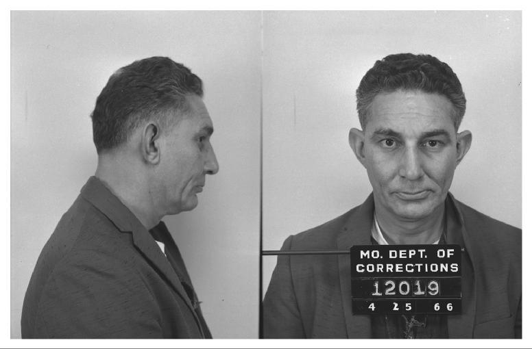
The Duane sailor picture shows (to my eye) very prominent protruding ear structure. Kids with ears like that were teased and called DUMBO, the Disney cartoon elephant who flew by flapping his ears.
I don't see such ears in the Cooper FBI sketches. Do ears like this on a a 16 year old youth tuck in more flush with the head as he ages? Georger?
377
QuoteSince I downloaded the latest GE, I figured I'd post some pics.
Georger likes cows, so there's some on that.
I id'ed some possible things that I wasn't clear on before in the area.
And I have a river flow possibility that suggests a location on the other side of the river where stuff may have landed on shore (cooper?), theorizing about how river flows work when the river meanders.
There is imagery from 1990 but it's b/w and fuzzy, so not including it, because no extra value
1) Fazio Sept 17 2002. Shows cows in South yard (picture right because E is top of picture) near the money find. Also note what I think is a cow feeding station.
2) Here's a picture of another cow feeding station farther N on the Fazio property. It looks identical to the one I labelled in 1)
3) This image from May 2002 is only slightly before the 1) photo, but it appears to show runoff collected W of that cow yard (the white "froth?"...) I've labelled my supposition. It's not "frothy" in other pics.
4) The July 26 2005 pic is interesting because I think it shows vehicles? on the beach, S of the money find, by the red roofed building there. I think these vehicles? aren't all there in other pics.
5) This July 2005 is the best modern pic. It's not dated beyond "July". What's interesting is that comparing it to the July 26 2005 pic, you can see there is at least one vehicle? on the beach by the red roofed building, that's not in this pic.
6) The white line with red points in this pic is me speculating about river flow, suggesting a point on the opposite shore that might have been worth searching in 1980. There are some place names in the river that come up (blue) from google earth that might be good for reference. You can see the dry Shilapoo Lake labelled, on the Fazio property.
(edit) some of my placemarks look like they're not on target, that's because I put them on one year's imagery, and cycled thru without changing their position. The google imagery skews slightly from 1990 to 2005. The July 2005 pic was my reference point for all.
Quote
Good photos. The last one stands out to me,
showing Catapillar island and how T_Bar projects
out into the Columbia. What year is this photo?
These photos compare favorably with the hi-res
images Ckret posted before . . .
Back later tonight -
I was able to read the US Navy, but it was interesting how you were about to do that picture to make it stand out.
I had read something about when the jumpers where being trained and they took a beret and stripped the stiff lining our to them after they made their first jump - Does anyone know if this beret was the beret that the trainees did that to?
Regarding the ears - note that his growth plate was not complete at 15...go look at your own high school Sophomore pics. As he aged they were NOT so prominent. Also note that between 1960 and the later yrs there appears to be some changes in the ear (I do not know why - they were doing a minor pinning surgery those yrs).
Note the when I combined the composites with the pictures - the ears on the composites were actually larger than Duane's ear????????? ![]() On one I had to actually sketch the composite ear to be larger. Try it yourself.
On one I had to actually sketch the composite ear to be larger. Try it yourself.
I posted information looking for answers to questions. I have not been doing a tease only telling what I can tell. I still have faith I am going to put Duane on that plane and in a chute.
Very tired right now - 2 days straight of nuclear medicine prep and scans (3 1/2 hrs) today. When I got home I went back to bed, but I am still exhausted. Good Night.
QuoteI was able to read the US Navy, but it was interesting how you were about to do that picture to make it stand out.
I had read something about when the jumpers where being trained and they took a beret and stripped the stiff lining our to them after they made their first jump - Does anyone know if this beret was the beret that the trainees did that to?
QuoteQuote
Good photos. The last one stands out to me,
showing Catapillar island and how T_Bar projects
out into the Columbia. What year is this photo?
These photos compare favorably with the hi-res
images Ckret posted before . . .
Back later tonight -
that photo with my white line in the river, is the most recent imagery in Google Earth. It's dated July 2005. Note I'm doing a little compression to fit in the 300KB limit here, but I don't think it's noticeable from the original.
It's pretty good. You can see people camping on the shore of Caterpillar Island, with tents and boats.
I've been looking at shore debris. Further North on the Vancouver side, it seems like wherever there's sand, there's an even distribution of logs/brush from the river, on the sand.
(I've posted on that before)
I thought the Ckret photos were labelled "CENPP" which I thought was an acronym for The U.S. Army Corps of Engineers, Portland District. I thought those photos were aerial, not satellite? Don't know if satellite would have been that good in '70s? and if available to Corps of Engineers?
(edit) On the logs, you can ask "where did that log come from, and why did it beach there?"
(edit) While the latest TBar imagery is from 2005, I notice that elsewhere in the US there is imagery as recent as July 2007. Don't know what the most recent area/data is.
Quotesee this link for pictures of paratrooper berets, if i am not mistaken they are similar colours in every army.
http://images.google.co.uk/images?sourceid=navclient&hl=en&rlz=1T4ADBF_en-GBZA312ZA312&q=paratrooper%20beret&um=1&ie=UTF-8&sa=N&tab=wi
QuoteJust seeing if there's anything interesting with this new historical GE imagery they just released.
Here's the area just N of the money find. I was interested in the rate of change of the shoreline. The pictures are taken at various water levels, so that changes things. But there's an inlet N of Tena Bar, that seems to get sand deposits.
In general thought, the river doesn't change quickly?
Quotegood thoughts, georger.
Here's one I have.
If we don't see significant sand shifting in the various photos, away from Tena Bar, then the "plumes" visible in the '74 Tena Bar photo become more significant. Because they did appear and disappear (i.e. they weren't in the earlier, or the later, photo from Ckret).. And what's interesting is one is very near the money find.
Because of their shape, and the presence of the pipeline dredges further N on the columbia in that picture (I went thru all this before) and the known dates of the dredging, I think strengthens the idea that the more significant sand movement was related to dredging, not erosion or natural forces.
Of course you could also say that little apparent shoreline sand movement strengthens a human plant story, especially when it seems the money was found near where people park right near the water (my recent posts..although it's in the more recent era, the roads appear to have been there since the '70s. (the gravel/dirt roads around the Fazios.
The people/car traffic doesn't seem to have changed much around the Fazios. The big changes were first the South sand operation, and then later the North Sand operation.
It appears to me that the South Sand operation started around the '74 dredging.
Now: if we ignore all this sand talk, and focus on river debris, then we're back where we started. River debris (wood) seems to be most everywhere. Don't know if much gets buried in sand. Maybe some does?

Yeah, the Navy titling on the hat was pretty clear. What was the mystery?
Jo has promised us that the fat lady would sing, but I don't hear anything yet.
377
Share this post
Link to post
Share on other sites